
Датотека:Sandy 2012-10-29 1515Z.png

Величина овог приказа: 800 × 450 пиксела. 5 других резолуција: 320 × 180 пиксела | 640 × 360 пиксела | 1.024 × 576 пиксела | 1.280 × 720 пиксела | 1.920 × 1.080 пиксела.
Оригинална датотека (1.920 × 1.080 пиксела, величина датотеке: 2,07 MB, MIME тип: image/png)
Опис измене
| Опис |
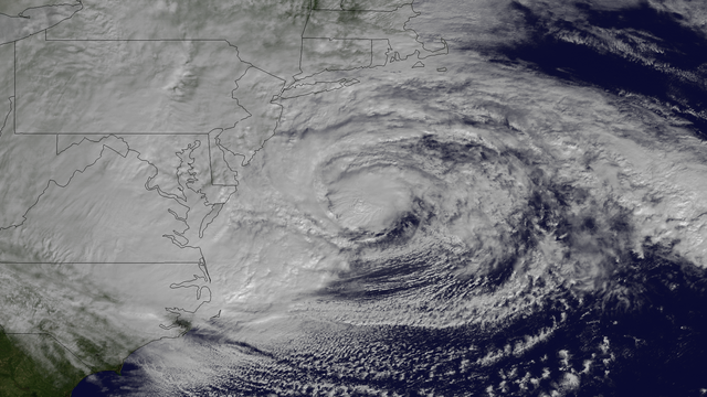
English: Hurricane Sandy, with winds of 90 mph and heavy rains, is creating dangerous flooding conditions all along the Northeast U.S. from NC to New England. This NOAA GOES-13 satellite image taken on October 29, 2012 shows the storm as it is centered off of Maryland and Virginia. The storm is heading in a northwestern direction towards the Delaware and southern New Jersey coast. |
| Датум | |
| Извор | http://www.nnvl.noaa.gov/MediaDetail2.php?MediaID=1223&MediaTypeID=1 |
| Аутор | The National Oceanic and Atmospheric Administration |
Лиценцирање
This image is in the public domain because it contains materials that originally came from the U.S. National Oceanic and Atmospheric Administration, taken or made as part of an employee's official duties.
|
Историја датотеке
Кликните на датум/време да бисте видели тадашњу верзију датотеке.
| Датум/време | Минијатура | Димензије | Корисник | Коментар | |
|---|---|---|---|---|---|
| тренутна | 08:27, 9. април 2018. | | 1.920 × 1.080 (2,07 MB) | A1Cafel | remove logo |
| 20:22, 29. октобар 2012. |  | 1.920 × 1.080 (1,93 MB) | Supportstorm | {{Information |Description ={{en|1=Hurricane Sandy, with winds of 90 mph and heavy rains, is creating dangerous flooding conditions all along the Northeast U.S. from NC to New England. This NOAA GOES-13 satellite image taken on October 29, 2012 show... |
Употреба датотеке
Следећа страница користи ову датотеку:
Глобална употреба датотеке
Други викији који користе ову датотеку:
- Употреба на el.wikipedia.org
- Употреба на fr.wikipedia.org